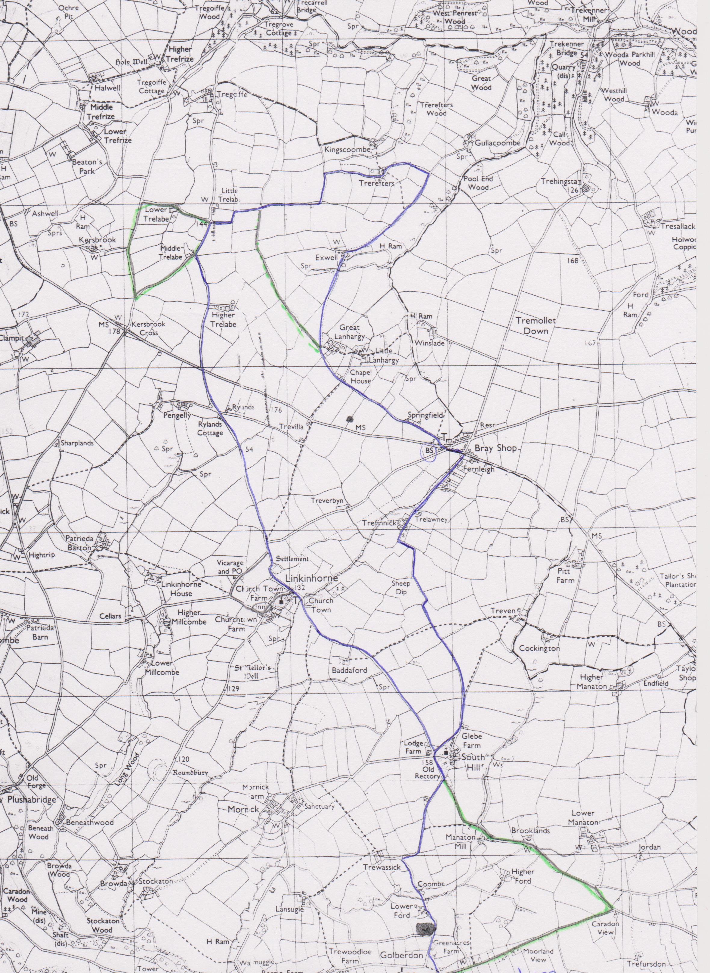
While the fields are so muddy, here’s a road walk via Bray Shop.
Can be 7, 8 or 9 miles total. After 5 – 6 miles stop at the Church House Inn, Linkinhorne for a break (The pub is now closed but the church is interesting)
From Golberdon Crossroads:
Take the South Hill Rd to St Sampson’s Church. You may find some South Hill Rocks around the building.
Take the Trefinnick Rd to Bray Shop.
Keep left at the busy main road, staying on the pavement, past the notice board and look around the corner of the barn and spot the BS Boundary Stone. Why SB?
Cross the road and walk down the Lanhargy Rd, past, Lavender cottage, Blagdon, Springfield cottages. (Opposite the Old Chapel House a footpath takes you to Linkinhorne, try when the fields are drier.)
At the entrance to Great Lanhargy Farm take the Exwell road on the right, which loops around through Trerefters. (If you want the 7 mile option, continue straight on here and don’t turn off to Exwell)
Keep left at the junction and left again at Middle Trelabe, then past Higher Trelabe.
At the junction TAKE CARE. This is the main Coads Green, Bray Shop Rd and a fast straight stretch.
Cross over, the sign says 1 mile to Linkinhorne and 2 miles to South Hill.
The wooden sign post further on has seen better days, the sign to Bray Shop is missing but at this junction at the field gate you’ll spot the waymarker for the footpath, the other end of the path from Lanhargy Chapel. Interesting to wonder how many people walked this route in the past.
Continue on … and as you round the bend and start down hill, take a right into the cemetery, follow the path and you’ll emerge on the corner.
Take a right to St Mellor’s church and the pub, (both interesting to explore) or continue straight on, past the red phone box to South Hill.
Retrace your steps by turning right past St Sampson’s church on the Golberdon road. A similar fate as the previous wooden signpost… the arm has come off.
OR for an alternative here and a little extra distance, go straight on past Higher Ford and Manaton, then turn right, at the Beech Tree, (Caradon View) and follow the road back to the crossroads .. you will have walked a total of 9 miles this way with views to Caradon Mast, Cheesering & Sharpe Tor.
This walk and others are laminated and can be found in the box on the seat in the parish hall porch at Golberdon crossroads. PL17 7ND
Any comments email events@south-hill.co.uk
Here’s looking forward to some drier, warmer weather soon.
Dog owners, most of the lanes are very quiet and you may feel you can let your dog run free, please be aware there are lots of sheep in the fields, some with lambs and some due to lamb, keep your dog within eye sight. This way you’ll also notice when it stops to “do it’s business”. There are no poo bins on this route, if you’re going to put it in a bag, carry it home DO NOT put plastic bags in the hedge, and never over the hedge, for many reasons, there are horses along the way and dog poo can have a devastating effect on them. Also dogs eating horse poo isn’t good either. Just be watchful and responsible.